


joet82
-
Posts
338 -
Joined
-
Last visited
-
Days Won
1
Content Type
Profiles
Forum
Gallery
ATV Magazine
Events Calendar
Downloads
Store
Community Map
Posts posted by joet82
-
-
I think AJM is cheating.....doubling up his invites. lol who really has 167 DIFFERENT people online.
and I'd be able to get a lot more if we were able to tap into my myspace friends list.
-
:laugh:now with that obama remark I agree with you 110%. haha
-
:iagreec:totally. I watched Palin's speech the other night and I must say I was pretty impressed!
I'm going to assume that celebrity moms can mostly be considered bad because they work and travel all the time. Especially those who are singers that tour? Just because a mom does not sit at home and devote 100% of her time to her children, that doesn't make her a bad mother. Many everyday America moms work a lot....what about those single moms who work two jobs to keep their children alive with food on the table. They can bust their butts working long hours around the clock to provide for their family, yet, because they're not with their children 24 hours a day they're bad??
Babies do require a lot of attention and have a lot of needs, but Trig Palin does have a dad, and I'm thinking he probably has a nanny that helps take care of him too.
McCain/Palin definitely get my vote.
:iagreec:My mom at one time, had 4 different jobs. She worked for the unemployment office, the Seattle PI (newspaper delivery), a substitute teacher, and a reserve police officer. Just to raise my sis and I. Don't tell me women with kids can't work.:usflag:
-
I'm the same way.
Same here, you have to clean them and get all the dirt, sand, salt, mud, etc off of them, or they will corrode and fall apart. I'm just too tired, and I don't store my quad on my property cause I have an apartment and they won't let me store my trailer at my complex.

-
And for those who are for obama cause he claims he'll pull us out of Iraq and Afghanistan as soon as he takes office.....The Iraqi Government and the Bush Administration have already laid out a plan to have our forces out by FY 2011....for those who don't know, that's October 2010....we have already turned over Falujia to the Iraqi forces, and continue to turn over the secure locations to them. There will still be reconstruction, so Those of us who have construction skills may be there longer, but THERE IS A PLAN. They can't announce it though cause then all Al Qaida will do is lay low, then as soon as it happens, they will errupt and go hay wire in the country....then guess who will be back in there. We can't announce a date cause of that....and if things come up before then, or if things get better before then, it will change the dates.
oh, and BTW, there have been more motorcycle deaths in the states in the last 6 months than there have been US military deaths in both Iraq and Afghanistan.
-
People like her have others watching over their kids in addition to the father. It would never be an issue if a man was in question.
But I still don't like McCain, he's too old, and too much miltary.
No matter how you look at it, it will be a historic event..whoever gets voted in.
By chosing her, he reaches out to Clinton supporters with his ticket. Good move to get in the White House.
what's wrong with the president being focused on his countries defense force? Personally I think it's the most secure job in todays economy.
Oh, and we still don't get paid the best.
-
yeah, my trailer does that. haha
-
John Tyler had 15 children....Zachary Taylor, Fredy and Teddy Roosevelt, George HW Bush and Grover Cleveland had 6....Andrew Johnson had 5....Abe Lincoln, Gerald Ford, Jimmy Carter, Ron Reagan and Ulysses S. Grant had 4....
And those were presidents....granted they were the fathers, but don't tell me raising kids in the white house can't be done.
-
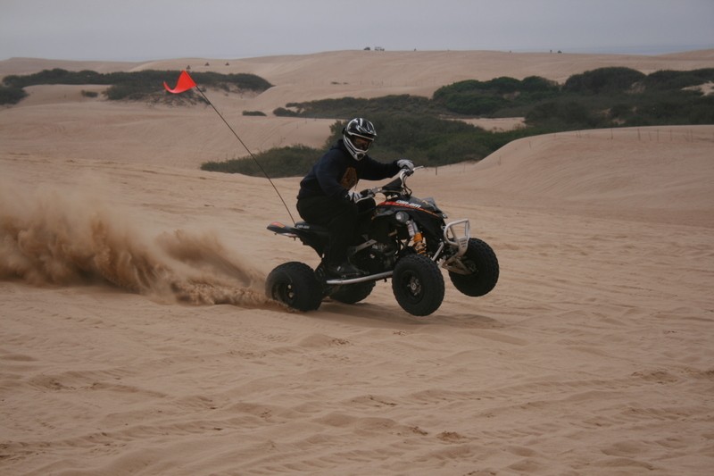
Quads are supposed to be dirty....that's the pics i have of her.
-
The only pics I have of her clean....
-
i want mccain, mainly cause i know he will treat the military better than obama ever would.
-
ya, I'm not interested in a steering column that's just an inch longer, but nearly double the price.
-
I found one by Houser that is +1 but it cost 300 bucks.
what do u mean, +1?
-
yup, believe so.
-
Well, when I took my quad for it's first ride in cali out ro Ballinger Canyon, I happened to get on a trail that I was too much of a pu*** for, cause I didn't know what was on the other side of the hills. Ended up stopping short on one hill, started sliding back, slid crooked, the wheels caught. I went one way, and Shiela rolled once and landed back on her wheels. The problem is that during the roll, she landed on the handlebars and bent the steering column. I have already called the dealership that I bought my quad from, they want 208.99 for it. and I found a website, Arctic Cat,Polaris,Suzuki,Kawasaki,Honda,Yamaha,Sea-doo,Can-Am dealer Muskegon, Michigan, that has it for 170.99. My question is, does anyone know where I can get a cheaper one. I think it's borderline outragious that I have to pay that much for a foot and a half long piece of steel.
btw, that's another thing that still trips me out....the ALUMINUM handlebars are perfect after the roll, yet the STEEL steering column wasnt....WTH! lol
-
wow, someone's got a fan! haha
-
Thnx guys. I do my part. Next deployment for me will be to one of the 2 war zones. they haven't told us yet, and we probably won't know for sure till a month before we leave. lol
But ya, any time anybody wants to ride in SoCal, let me know. I'll see if a weekend is free, and i have the money to spare for gas. Central Cali, SONevada and AZ will need a long weekend, or Leave...but I can go anywhere in the west with that depending on how long my leave is, and of course gas money.
-
U r welcome. I have a 'subscription' to Trailsource.com that's where I got the info.
-
Posted a few pics in the trail riding section. Check em out.
Sry I didn't accept the invite you gave me. maybe next time I have a long weekend or I'm on leave, I'll take you up on it.
-
Ahh yes... The world renown romantic international honeymoon destination that is Eureka CA???
ya, my thoughts too, but its their choice.
-
alrighty...here's some for the Bend area.
REGION: Deschutes National Forest TITLE: Edison Butte OHV Trail System
NOTES: West of Bend, the Edison Butte area has 25 miles of trails. To reach the trailhead from Bend, head west on SR46 for 8 miles.
The Edison Butte Trail System, about 25 miles long, is located on the slopes of Kwolh Butte and Sheridan Mountain, west of Bend. The recommended riding season is late June to October because of the high elevation and tendency of snow to cover the trail into the spring and summer months. Currently, no specific OHV signing exists. Riders must obtain a map and follow orange snowmobile diamonds and junction numbers.
The trail system goes through ponderosa pine and manzanita forest in the lower elevations, near the Edison Sno-Park and goes up into stands of hemlock trees near Kwolh Butte and Sheridan Mountain. The volcanic terrain can be challenging because there are many loose rocks and lava ridges to go over. As a result, the trails are considered “More Difficult.” Two snowmobile shelters are situated along the trail, and the Kwolh Butte shelter has impressive views of the Central Oregon Cascade Mountains.
To reach the trailhead from Bend, take the Cascade Lakes Highway (Hwy 46) 18 miles west of Bend toward Mt. Bachelor, turn left at the Sunriver exit and travel another 6 miles south on Road 45. Turn right at the Edison Sno-Park sign.
REGION: Deschutes National Forest TITLE: East Fort Rock OHV - Camp II Trailhead
NOTES: East of Bend, the East Fort Rock OHV Trail System has 318 miles of trails over 110,00 acres. The East Fort Rock OHV trail system lies on the east side of the Bend/Fort Rock Ranger District of the Deschutes National Forest. Trails are well signed and mapped and provide a full range of difficulty from easiest to most difficult. There are two staging areas, two trailheads, and four designated play areas. The trail range in elevation from 4400 to 6400 feet.
The trail system is designed for Class I and Class III ATVs which are ATVs (quads or three-wheelers) and motorcycles less than 50 in width. East Fort Rock is not an OHV park. Off-highway vehicles are allowed on designated routes and areas only. The trails are open to horses, mountain bikes, and other recreationists, so please watch for others and ride sharefully.
The trail system is open all year, however hot, dusty conditions normally inhibit riding from mid-July through September and cold, snowy conditions inhibit riding from mid-December through March. About half of the project area is within the Fox Butte Green Dot Area which restricts access to designated roads during the general deer hunting season. This is roughly a two-week period form late September to mid-October, and any roads or trails within the Green Dot Area will be subject to Green Dot restrictions. Individual trails may be temporarily closed for maintenance or reconstruction or to provide resource protection.
To reach the Camp II trailhead from Bend, Hwy. 20 east about 20 miles. After crossing the Horse Ridge Summit, turn right on the second road, Spencer Well Road (paved Road 23). Proceed south for 5.5 miles until the road forks. Take paved Road 25 to the right and follow the signs to the Camp II Trailhead.
Note: As of September 2007, ATV riding is permitted on Forest Service roads with vertical number signs as long as the ATV has a valid Oregon OHV sticker. ATV riding is not permitted on any Forest Service road with a horizontal number sign.
REGION: Deschutes National Forest TITLE: East Fort Rock OHV - South Lava Trailhead
NOTES: East of Bend, the East Fort Rock OHV Trail System has 318 miles of trails over 110,00 acres. The East Fort Rock OHV trail system lies on the east side of the Bend/Fort Rock Ranger District of the Deschutes National Forest. Trails are well signed and mapped and provide a full range of difficulty from easiest to most difficult. There are two staging areas, two trailheads, and four designated play areas. The trail range in elevation from 4400 to 6400 feet.
The trail system is designed for Class I and Class III ATVs which are ATVs (quads or three-wheelers) and motorcycles less than 50 in width. East Fort Rock is not an OHV park. Off-highway vehicles are allowed on designated routes and areas only. The trails are open to horses, mountain bikes, and other recreationists, so please watch for others and ride sharefully.
The trail system is open all year, however hot, dusty conditions normally inhibit riding from mid-July through September and cold, snowy conditions inhibit riding from mid-December through March. About half of the project area is within the Fox Butte Green Dot Area which restricts access to designated roads during the general deer hunting season. This is roughly a two-week period form late September to mid-October, and any roads or trails within the Green Dot Area will be subject to Green Dot restrictions. Individual trails may be temporarily closed for maintenance or reconstruction or to provide resource protection.
To reach the South Lava trailhead from LaPine, head east on Finley Butte Road (CR22) for 24 miles. Follow the signs to the South Lava trailhead.
REGION: Ochoco National Forest TITLE: Millican Plateau OHV Trail System
NOTES: Southeast of Bend near Prineville, the Millican Plateau OHV Trail System is managed by the Prineville District of the BLM. The Plateau provides a variety of desert riding experiences from easiest to more difficult. There are 111 miles worth of trails for Class I/III OHV's, of which 37 miles are also open to Class II OHV's. The Four Corners Staging Area has an information kiosk providing maps and information for riders.
The Millican Plateau offers a true desert riding experience. The soils are mostly sand with rock outcrops and the vegetation is a mixture of sagebrush and juniper. The best riding season is during the winter when there is good ground moisture. There are only a couple of weeks during the winter when the trails are not rideable due to snow or frost.
The Millican Plateau is open for riding year round. During the summer, hot, dry, dusty conditions may inhibit riding. Individual trails may be closed temporarily for maintenance and reconstruction or to protect resources. Extreme fire conditions or snow may also close the Plateau for short periods of time.
To reach the trailhead from Bend, follow Highway 20 east about 4 miles and turn left on the Powell Butte Highway. Go about a half mile and turn right on Alfalfa Market Road. Once you have turned onto Alfalfa Market Road it is 16 miles to the Four Corners Staging Area. Alfalfa Market Road turns into Willard Road which turns into SW Reservoir Road. Follow SW Reservoir Road to a four-way intersection (Four Corners) where SW Reservoir Road meets the Millican Road. Continue east 1/8 mile and follow signs to Four Corners OHV Staging Area.
If you need the maps to the areas, I can email them to you if needed.
-
I have never been riding in that area, but here's what I can find:
California
Samoa Dunes Recreation Area
NOTES: West of Eureka on Humboldt Bay, the Samoa Dunes Recreation Area has 140 acres of open ATV riding. It connects with the new 75 acre Eureka Dunes about 1 mile north of Samoa.
To reach the trailhead from the intersection of US 101 and SR 255 in Eureka, head north on SR 255 across the bay. Travel 2 miles. Turn left on New Navy Base Rd. Go 4.75 miles and turn right onto Bunker Rd. Look for parking.
Oregon:
REGION: Siskiyou National Forest TITLE: McGrew 4WD Trail
NOTES: West of Medford and southwest of Cave Junction, the McGrew 4WD Trail is a remote 20 mile route. The trailhead is located 15 miles southwest of Cave Junction on US199.
I can go further out if you're willing to travel further.
-
I have the 360....used to have PS2, but Halo converted me. haha
As for games. I have Forza 2, Rainbow 6 Vegas, R6V2, Halo 3, Battlefield: Bad Company, Madden 09, and Head Coach 09.
-
yeah, but you do have 2 times the chances of getting the prizes.


 Posted a few pics in the trail riding section. Check em out.
Nice and Clean
in ATV Picture and Video Sharing
Posted
I'm not looking at the trikes....except for the Spyder. course, I'm wanting to know who the ladies are with him in the second spyder pic....