
mikeexplorer
-
Posts
884 -
Joined
-
Last visited
-
Days Won
103
Content Type
Profiles
Forum
Gallery
ATV Magazine
Events Calendar
Downloads
Store
Community Map
Everything posted by mikeexplorer
-

Tuff Lift for UTV and ATV Hauling
mikeexplorer replied to Ajmboy's topic in ATV Trailers, Haulers, and Attachments
Neat idea, hate to think what it costs -
You found your problem Mike
-
It is possible they sent you a bad unit, keep us posted
-
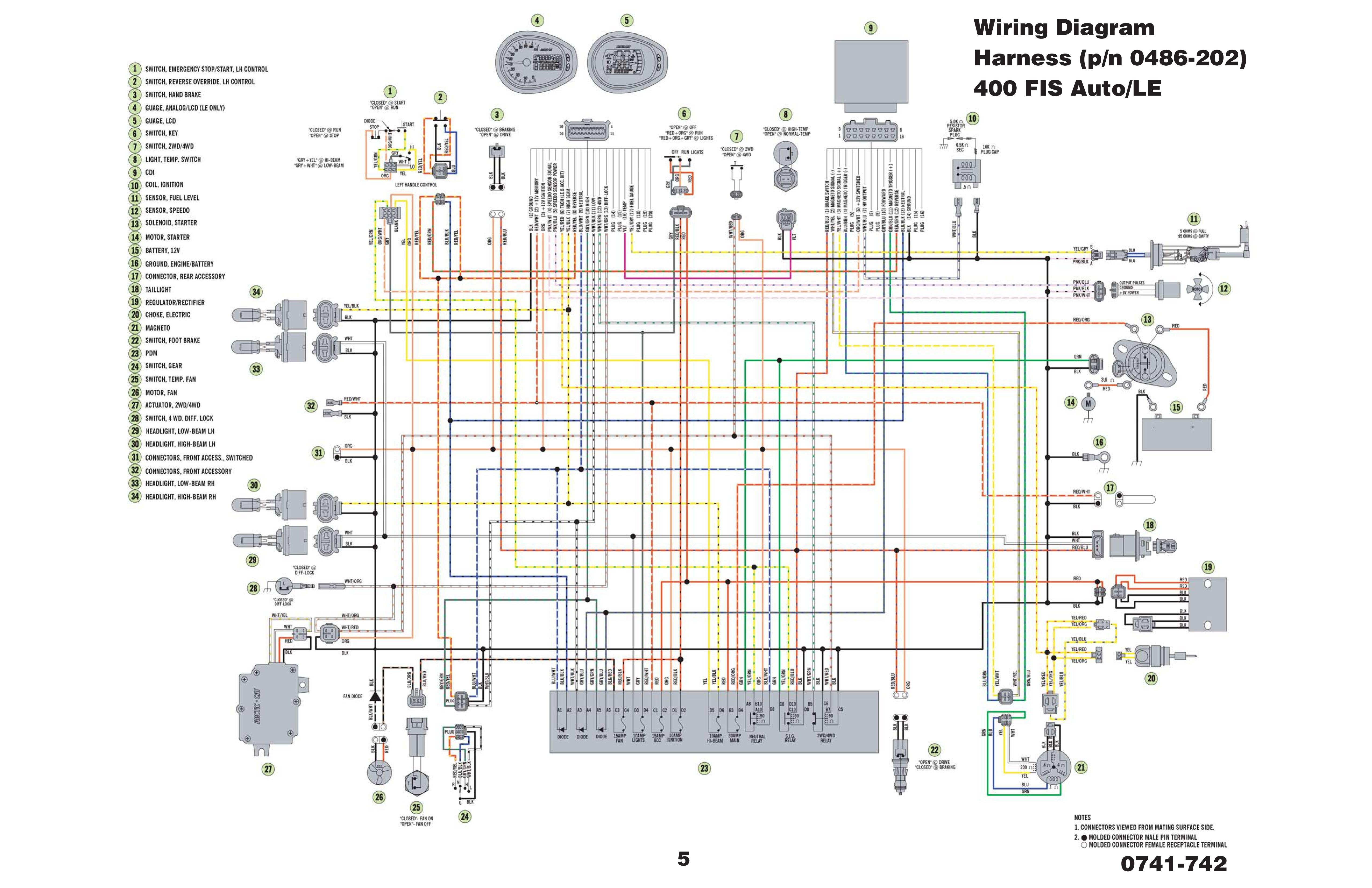
Here is the schematic, looks at item 21 lower right corner, that is the stator, the three black wires are the AC volts for the charging system, the other four wires are the trigger for spark. The 2007 400 models were known for wire harness problems. The service manual is in the link below. You will have to check to make sure you don't have broken wires from the sensor to the CDI. 2006 and earlier models did have an issue with the stator magnets becoming unglued, but this was solved in the 2007 models. I had that machine for 9 years and put 16,000 miles on it and never had a stator problem. I did have wiring harness problems twice. The service manual should have the procedure to test the spark trigger. Mike http://www.mymowerparts.com/pdf/Arctic-Cat-ATV-Repair-and-Service-Manuals/arctic_cat_2007_400_500_650_700_service_manual.pdf

-
Easy test is with a meter on the battery, should read 12-13 volts with the machine off, start it up and rev it a bit, should read 13.5 -14.5 volts. Mike
-
No electric on 2007 arctic cat 400 atv
mikeexplorer replied to Corbean's topic in Arctic Cat ATV Forum
I owned that exact ATV and that model was known for wiring harness problems. You will need a multimeter and the schematic. It is located here. http://www.mymowerparts.com/pdf/Arctic-Cat-ATV-Repair-and-Service-Manuals/arctic_cat_2000_thru_2009_atv_and_snowmobileSnow_Wiring_Diagrams__NOTE_LARGE_FILE_459mb.pdf The diagram shows the color codes for each wire. First I would check if you have voltage to the ignition key. Then turn the key and see of the other wires get voltage, it could be as simple as a bad ignition switch, but I am betting the wire is broken between the ignition fuse and the key switch. I do have pictures of when I had to repair the harness on that machine I can dig up if you think it would help. I can show the exact spot on the frame where the harness shorted out, and how to prevent it from happening once it is repaired. Mike -
Upstate New York does have ATV riding, Tug Hill https://adirondackstughill.com/things-to-do/atv-riding/
-
There are after market kits to add that feature if you want. I found this kit online here. https://www.ebay.com/itm/Arctic-Cat-1000-250-300-400-500-550-650-700-Tusk-ATV-Horn-Light-Turn-Signal-Kit/292537799878?ssPageName=STRK%3AMEBIDX%3AIT&_trksid=p2057872.m2749.l2649 I already had the quads wired with a horn so if during a group ride you need to get the rider in front of you's attention, its easy The only thing this kit does not do is give you reverse lights. I added that on my own with a small strip of white LED lights. The reason I did this is because of the Northcentral ATV project, we will be interacting with vehicles more, as township roads are opened to ATV use to allow making connections to different trail systems and towns. Most drivers do not understand hand signals so I figured adding this kit will make it better for vehicles to know your intention. Even now the connection trail from Snow Shoe Rails to Trails and Bloody Skillet ATV area uses township roads to make the connection so it does come in handy to be able to signal vehicles of your intentions.
-
Apache Backcountry Tracks Review 31 Mar 2018
mikeexplorer replied to Gunny's topic in ATV Picture and Video Sharing
Good video, excellent comparison and good review -
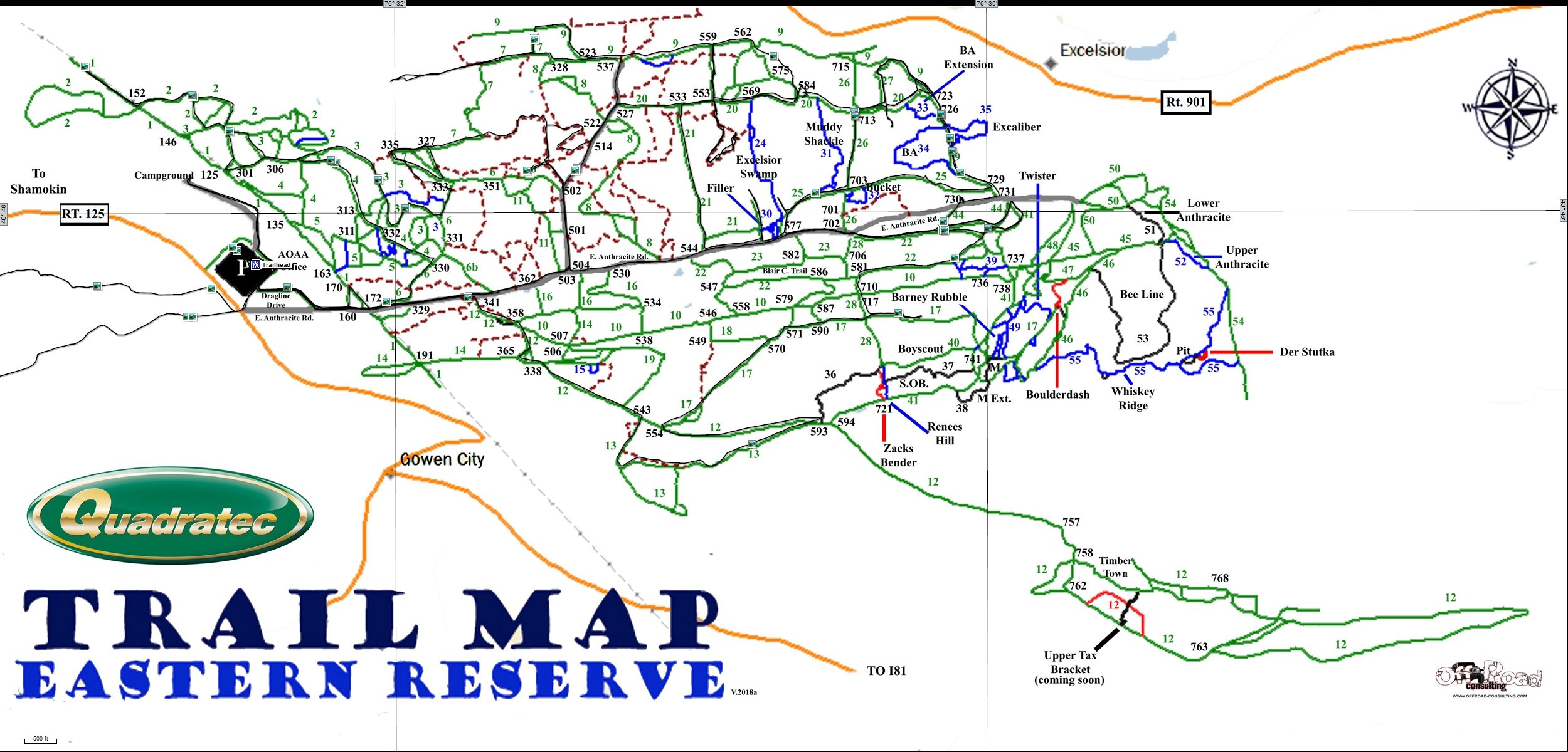
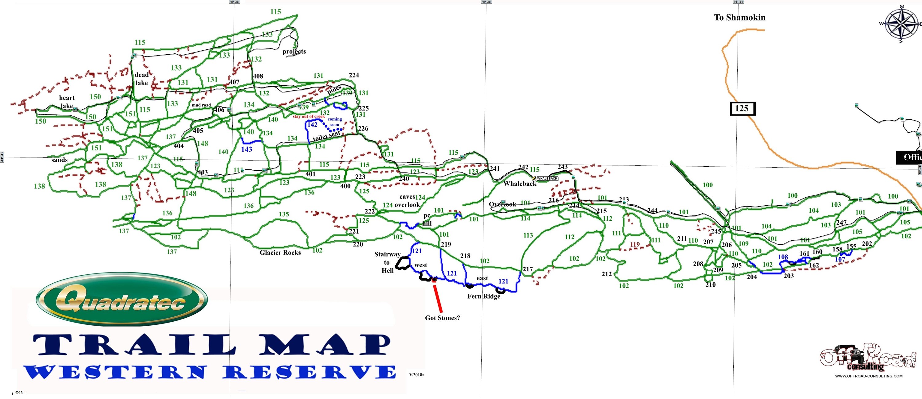
AOAA only provides their maps for using a gps is via the maprika app on phones, which I always do not like to use on the trails. (the phone that is) They do have paper maps at the trailhead, but I was able to get them to send me a PDF of the trail maps and now calibrated them so they can be uploaded into a GPS unit. Here they are attached. The western map is off on the left side, based on actual tracking data I have from riding the trails. I did my best to compensate, but changing to aerial view, shows the problem is their map, the tracks are right on the money with aerial view. For other PA riders, I have calibrated maps for some of the state trails like Whiskey Springs, Bloody Skillet, Denton Hill (Potter County), and Dixon Miller. If anyone is interested, this website allows me to upload KMZ file. AOAA - East.kmz AOAA - West.kmz
-
2015 Arctic Cat TRV500 getting water in crankcase!!
mikeexplorer replied to Bob Heckendorf's topic in Arctic Cat ATV Forum
Does the water get into your belt system? Here is a link for the service manual, you can look through it to see for a breather for the engine and how its supposed to be attached. https://support.countrycat.com/posts/2799445-2015-500-1000-service-manual -
2008 Arctic Cat 500TRV Transmission noise
mikeexplorer replied to kennyg833's topic in Arctic Cat ATV Forum
Check your shift linkage, it may need adjusting. Service manual with the procedure is here http://www.mymowerparts.com/pdf/Arctic-Cat-ATV-Repair-and-Service-Manuals/arctic_cat_2008_400_500_650_700_700H1_service_manual.pdf -
Generate map of private ATV trails
mikeexplorer replied to Hank Montgerard's topic in Where To Ride Your ATV
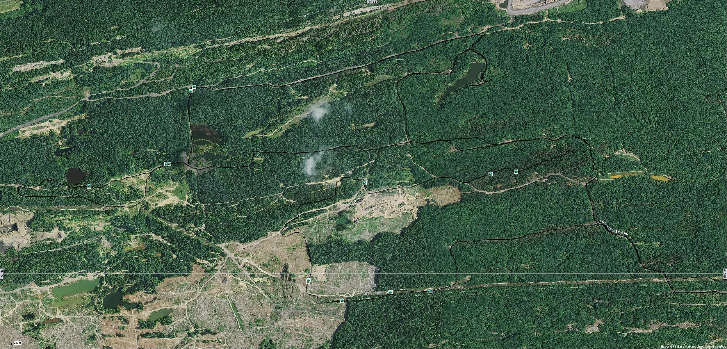
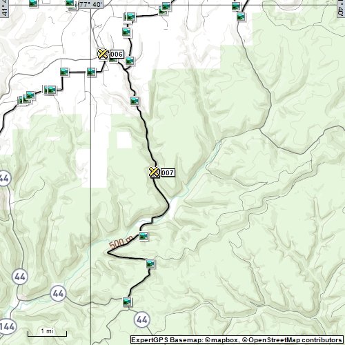
The software I use is for windows only, but I am sure there is something similar out there for IOS. Take this example, we rode this abandoned roads, stopped, turned around and went back the way we came but then continued in a different direction. By zooming in at the start and end points I can see the points that made the track. All I do is use the scissor tool to split the track at both ends then delete one of them. Now if I look at the track of this old road, it will show the true distance (one way of course) I then closed the track for the curved part to make it one track. I left the other track there unconnected, but my software allows a "Y" track. The "X" shown are where I made waypoints, the blue boxes are where I took pictures. This software can also take pictures from a camera and use the tracking data to geo tag photos, provided the clock is set in the camera. I attached an actual picture taken at that location, I am not sure if uploading it strips off the geo-tag info. If not, you can open the picture and see exactly where I took the picture. Hope that helps. Mike
-
2003 Arctic Cat FIS 500 Steering Problem
mikeexplorer replied to Jerry Redhage's topic in Arctic Cat ATV Forum
First, here is a link for the service manual for your machine http://www.mymowerparts.com/pdf/Arctic-Cat-ATV-Repair-and-Service-Manuals/Arctic-Cat-2003-ATV-Service-Manual/ One of the sections will explain how to check the steering, tie rods, and castor. First thing to do is check the front tire pressures. If one tire is low, the quad will want to pull in that direction. Mike -
Weird, the app is not compatible with my tablets
-
Welcome, I have skied in Vermont but I was always told ATV riding is limited and they don't have many trails for ATV users. Mike
-
It eliminates engine braking. Personally I like engine braking, but if you don't, remove the bearing. Mike
-
They finally got around to updating the PA section, it had out of date information
-
The most common issue with a Cat quad blowing the IGN fuse as soon as you turn the key on is a rubbed wire in the harness. I would need the year, make & model to pull up the exact wiring diagram for the machine. Typically the IGN fuse powers a few things, like the 4X4 actuator, temp sensors, and such. You can try disconnecting a few items to see if that is it. Unplug the starter relay (just the smaller connector) but I doubt that is it. shorts in the 4 x 4 actuator are known, disconnecting it and trying a fuse is worth while to do. Common areas for wires to rub through are around the steering column and front part of the quad where wires run down vertically on the frame. Mike
-
Check your ignition fuse first, then check to see if you have voltage to the ignition switch and when you turn the key to the on position that it closes.
- 9 replies
-
- 1
-

-
- 300
- arctic cat
- (and 1 more)
-
Post your question in the Arctic Cat section, people will see it
-
Garmin Rino 700 series trail maps?
mikeexplorer replied to Steve Shane's topic in General ATV Discussion
What I use is called ExpertGps. The home version. https://www.expertgps.com/ You can draw your own maps or overlays and export them to KMZ and upload them right into your unit. There are times I will make tracks and points and upload them right from the software. I use this software for multiple applications so its worth it to me to own a copy. Mike -
ACat H1 700 EFI 2010 no start
mikeexplorer replied to chevelletoarctic's topic in Arctic Cat ATV Forum
If you had bad gas it probably clogged the injector. you will have to try some injector cleaner Mike -
Garmin Rino 700 series trail maps?
mikeexplorer replied to Steve Shane's topic in General ATV Discussion
I have the Garmin Oregon 450t. It has the 100k Topo map built into it and I have used custom maps frequently. The format for a custom map is KMZ which is also known as a Google Earth file. (if you open the file on your computer, Google Earth will display it) To copy a custom map, connect it to your computer, you should see two removable drives open up. You want the one that refers to the SD card (usually the higher drive letter), copy the KMZ file into: X:\Garmin\CustomMaps (X is the drive letter of the SD card) Now on my unit, to display the map is: Setup -> Maps -> Select Map, will show what maps are on the SD card, touch it and then select "Enable" , you may or may not want to turn off the built in map depending on how it looks on screen, it may be too cluttered with both maps on. I have software where I can make my own maps from any JPG or PDF file. It is not free, but there may be free options out there, do a online search, I think you can do it with Google Earth. I have taken maps of ATV trail systems and did this so I can see exactly where I am on the trails, I also use it for other hobbies and really like this feature. Mike -
Spark plug could have gone bad, I owned this exact machine, I had a crack in the spark plug boot once, I replaced the coil & boot as one assembly, it was only a few bucks more to replace both. but change the plug first
.jpg.0b059ad97fd50ed5efcf6f255cd02e08.jpg)
.jpg.a2f74d4b7b99e518fb5ee258f0bb5e34.jpg)
.jpg.c9ac8ea678177880ec5c4d65087103a4.jpg)

.JPG.3cf86669f7201e97112dc30b105566a0.JPG)